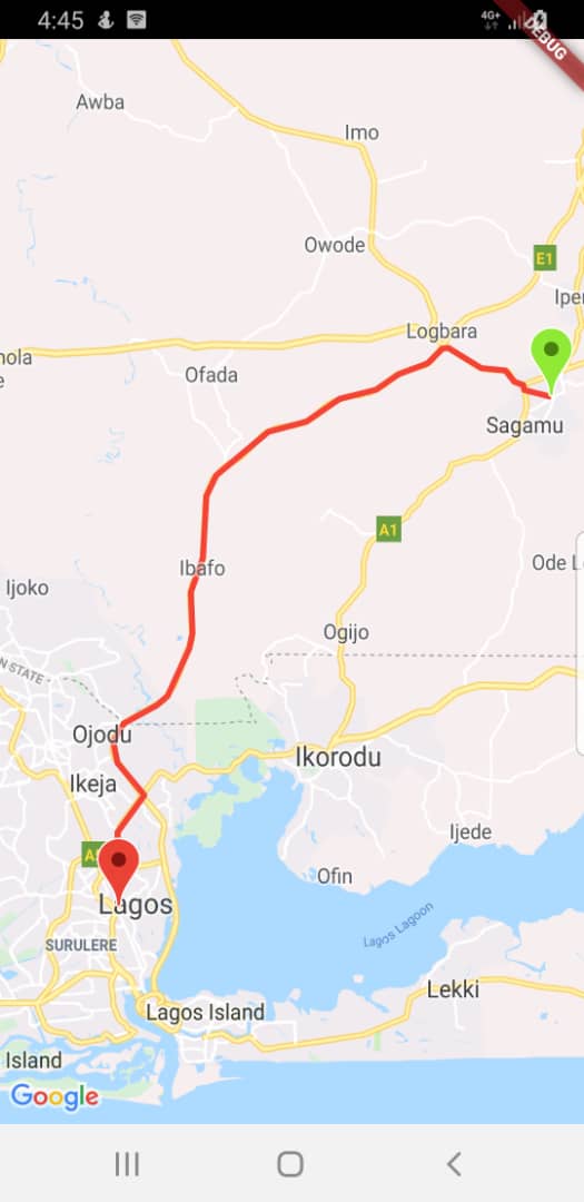
Flutter谷歌地图多段线点计算插件flutter_google_map_polyline_point的使用
Flutter谷歌地图多段线点计算插件flutter_google_map_polyline_point的使用
flutter_googleMap_polyline_point
这是一个Flutter插件,用于将编码的Google多段线字符串解码为适合在地图上显示路线或多段线的地理坐标列表。该包是flutter_polyline_points包的扩展。

|
开始使用
此插件包含了解码Google编码多段线字符串的功能,该功能返回一个坐标列表,表示两个地理位置之间的路线。
导入包
在你的Dart文件中添加以下导入语句:
import 'package:flutter_polyline_point/flutter_polyline_point.dart';
第一种方法
通过地理坐标获取点列表。这将返回一个PolylineResult实例,其中包含API的状态、错误消息以及解码后的点列表。
// 初始化PolylinePoints对象
PolylinePoints polylinePoints = PolylinePoints();

// 获取路线信息
PolylineResult result = await polylinePoints.getRouteBetweenCoordinates(
  googleAPiKey, // Google API Key
  _originLatitude, _originLongitude, // 起点坐标
  _destLatitude, _destLongitude // 终点坐标
);

// 打印结果中的点列表
print(result.points);
第二种方法
解码一个编码的Google多段线字符串。例如,_p~iF~ps|U_ulLnnqC_mqNvxq@。
// 解码多段线字符串
List<PointLatLng> result = polylinePoints.decodePolyline("_p~iF~ps|U_ulLnnqC_mqNvxq`@");

// 打印解码后的点列表
print(result);
更多关于Flutter谷歌地图多段线点计算插件flutter_google_map_polyline_point的使用的实战系列教程也可以访问 https://www.itying.com/category-92-b0.html
更多关于Flutter谷歌地图多段线点计算插件flutter_google_map_polyline_point的使用的实战系列教程也可以访问 https://www.itying.com/category-92-b0.html
当然,以下是如何在Flutter项目中使用flutter_google_maps_polyline_point插件来计算多段线(Polyline)上的点的示例代码。这个插件可以帮助你在Google地图上绘制平滑的曲线,并且可以通过插值计算出曲线上的任意点。
1. 添加依赖
首先,在你的pubspec.yaml文件中添加flutter_google_maps_polyline_point依赖:
dependencies:
  flutter:
    sdk: flutter
  google_maps_flutter: ^2.1.1  # 确保你也添加了google_maps_flutter依赖来显示地图
  flutter_google_maps_polyline_point: ^0.2.10  # 检查最新版本号
2. 导入包
在你的Dart文件中导入必要的包:
import 'package:flutter/material.dart';
import 'package:google_maps_flutter/google_maps_flutter.dart';
import 'package:flutter_google_maps_polyline_point/flutter_google_maps_polyline_point.dart';
3. 设置Google Maps API密钥
确保你的AndroidManifest.xml和Info.plist文件中已经配置了Google Maps API密钥。
4. 编写代码
下面是一个完整的示例,展示如何使用flutter_google_maps_polyline_point插件来计算并显示多段线上的点:
void main() {
  runApp(MyApp());
}

class MyApp extends StatelessWidget {
  @override
  Widget build(BuildContext context) {
    return MaterialApp(
      home: MapScreen(),
    );
  }
}

class MapScreen extends StatefulWidget {
  @override
  _MapScreenState createState() => _MapScreenState();
}

class _MapScreenState extends State<MapScreen> {
  GoogleMapController? _controller;
  Set<Polyline> _polylines = {};
  Set<Marker> _markers = {};

  final LatLng initialPosition = LatLng(37.7749, -122.4194);

  @override
  Widget build(BuildContext context) {
    return Scaffold(
      appBar: AppBar(
        title: Text('Google Maps Polyline Example'),
      ),
      body: GoogleMap(
        mapType: MapType.normal,
        initialCameraPosition: CameraPosition(
          target: initialPosition,
          zoom: 14.0,
        ),
        onMapCreated: (GoogleMapController controller) {
          _controller = controller;
          _addPolylineAndMarkers();
        },
        polylines: _polylines,
        markers: _markers,
      ),
    );
  }

  Future<void> _addPolylineAndMarkers() async {
    // 定义多段线的起点和终点
    final List<LatLng> polylineCoordinates = [
      LatLng(37.7749, -122.4194),
      LatLng(34.0522, -118.2437),
    ];

    // 使用flutter_google_maps_polyline_point插件计算多段线上的点
    final PolylinePoints polylinePoints = PolylinePoints();
    final List<List<double>> points = polylinePoints.decodePolyline(
      polylinePoints.getRouteBetweenCoordinates(
        polylineCoordinates.map((e) => e.latitude!, e.longitude!).toList(),
        apiKey: 'YOUR_GOOGLE_MAPS_API_KEY',  // 替换为你的API密钥
      )!,
    );

    // 创建Polyline
    final Polyline polyline = Polyline(
      polylineId: PolylineId('polyline_id'),
      color: Colors.blue.withOpacity(0.7),
      width: 4,
      points: points.map((list) => LatLng(list[0], list[1])).toList(),
    );

    setState(() {
      _polylines.add(polyline);

      // 添加起点和终点Marker
      _markers.add(Marker(
        markerId: MarkerId('start'),
        position: polylineCoordinates.first,
        infoWindow: InfoWindow(title: 'Start', snippet: 'Start Point'),
      ));
      _markers.add(Marker(
        markerId: MarkerId('end'),
        position: polylineCoordinates.last,
        infoWindow: InfoWindow(title: 'End', snippet: 'End Point'),
      ));

      // 添加多段线上的一个中间点Marker(例如第10个点)
      if (points.length > 10) {
        _markers.add(Marker(
          markerId: MarkerId('middle'),
          position: LatLng(points[10][0], points[10][1]),
          infoWindow: InfoWindow(title: 'Middle', snippet: 'Middle Point'),
        ));
      }
    });
  }
}
注意事项
- API密钥:确保你已经替换了
YOUR_GOOGLE_MAPS_API_KEY为你的实际Google Maps API密钥。 - 权限:在Android和iOS项目中,确保你已经正确配置了必要的权限和API密钥。
- 依赖版本:检查
flutter_google_maps_polyline_point和google_maps_flutter的最新版本,并根据需要进行更新。
这段代码展示了如何使用flutter_google_maps_polyline_point插件来计算并显示多段线上的点,并在地图上添加起点、终点和中间点的Marker。


